JASMIN

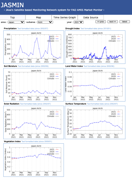
JAXA’s Satellite based MonItoring Network system for FAO AMIS Market Monitor (JASMIN) provides satellite derived agrometeorological information including precipitation, drought index, soil moisture, solar radiation, land surface temperature, and vegetation index. The tool is able to generate two types of
product for each parameter – current condition, and anomaly, which is the deviation from past years’ averages. JASMIN can generate either a map of the whole country or time series graphs at a number of predefined locations. The outputs assist the ASEAN Food Security Information System (AFSIS) and target
country agricultural statistics experts in preparing AMIS outlooks for Asia-RiCE.

Access

INAHOR

JAXA has also developed the INAHOR (INternational Asian Harvest mOnitoring system for Rice, crop planted area estimation software) tool to assist AFSIS and target countries’ agricultural statistics experts in preparing AMIS outlooks for Asia-RiCE. Through an Asian Development Bank Technical Assistance project and SAFE projects under APRSAF, INAHOR (using ALOS-2) has been demonstrated to achieve mapping accuracies of 80-90% for target provinces in Laos, Thailand, Vietnam (North), Philippines, Myanmar, Cambodia, and Indonesia. A machine learning version of the software was developed in 2018. Higher accuracies can be achieved with this new version.

The INAHOR tool and derived rice planted area maps have been used for many projects including the 2020 CEOS Chair Initiative and to improve rice cultivated area statistics in Cambodia (APRSAF/SAFE Rice Mapping Project).

More Info

VEDAS


Visualisation of Earth Observation Data and Archival System (VEDAS) is a repository developed by the Indian Space Research Organisation (ISRO) that provides easy access to satellite data. Through VEDAS, spatio-temporal analysis can easily be done, such as data visualisation, analysis like multi-temporal profiling, multi-temporal analysis, feature classification, image composites, etc. VEDAS has a simple land cover classification algorithm (thresholding method).

ISRO’s precipitation data provision system was developed and can be openly accessed through VEDAS. The data are utilised to generate monthly AFSIS’s RGO report by agricultural statisticians in ASEAN. Site Link: https://vedas.sac.gov.in/AFSIS/

JAXA has also shared ALOS-2 ScanSAR data for the period 2018 -2022 for the Asian region through the VEDAS system, including more than 1,000 scenes covering parts of India, Sri Lanka and Thailand.

Site Link: https://vedas.sac.gov.in/vegetation-monitoring/index.html

More Info